

|
|
|---|
|
American Politics Journal Atrios Barry Crimmins Betty Bowers Buzzflash Consortium News Daily Howler Daily Kos Democatic Underground Disinfotainment Today Evil GOP Bastards Faux News Channel Greg Palast The Hollywood Liberal Internet Weekly Jesus General Joe Conason Josh Marshall Liberal Oasis Make Them Accountable Mark Morford Mike Malloy Political Humor - About.com Political Wire Randi Rhodes Rude Pundit Smirking Chimp Take Back the Media Whitehouse.org More Links |
| Catching
the FBI in a Big Fat LieOn
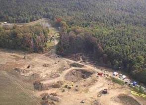
September 11, 2001, United Airlines Flight 93 crashed into a reclaimed
strip mine in
Somerset County, Pennsylvania. According to the FBI, the aircraft impacted intact after an apparent struggle in the cockpit between determined terrorists and equally determined passengers. The FBI released this photo shortly after the crash.
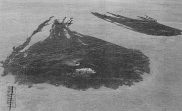
The Pennsylvania Department of Environmental Protection released this photo a few days later.
The pattern of impact is consistent with an aircraft
with significant lateral movement,
NOAA records indicate an average windspeed that
day of between 7 and 8 knots, with a maximum sustained
Except.... Look at this photo of an SR-71 crash in 1967.
Faithful Bartcop
The grass in this farmer's field is similar to
that replanted in stripmine reclamation projects.
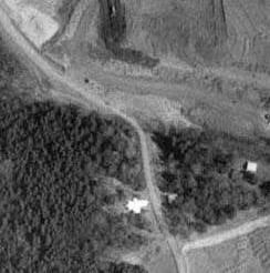
Except.... In order to put the photos in perspective, I obtained
DOQ (Digital Orthophoto Quadrangle)
This showed two important things. First, that the impact indeed
occured on the border between
Second, and much more importantly, it showed me which way was
north.
Clearly, the photos from the FBI and PDEP show a fan pattern which indicates
The debris the FBI contends was blown by the wind was found several
This means simply that the debris separated from the aircraft before
it hit the ground,
The debris could simply have been dropped from the moving plane.
A bomb detonation within the fuselage is equally unlikely, considering
the size of the
The third, and most likely cause, was a minor but fatal explosion of
an engine, which
Given the situation, in the most likely culprit in an engine explosion
would be an air-to-air missile,
That last is speculative; the information before it is not.
|
|

Send e-mail
to Bart | Discuss
it on The BartCop Forum | Comment
on it at the BartBlog